177K CUT
The itinerary 2025
From San Candido to Tarvisio
Discover the legendary 4 stages of 177k CUT
4 stages totalling 193 km and 11,460 m difference in altitude
1st STAGE
FROM SAN CANDIDO TO VAL VISDENDE
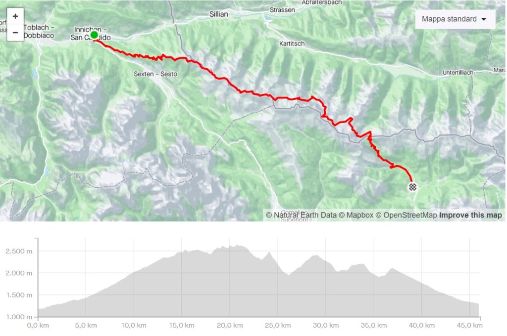
Departure is from Via Peter Paul Rainer 16 and immediately outside the village, take the forest road up to Monte Elmo. From here, continue at high altitude on well-trodden paths, following the signs for the Sillianer Hutte. Beyond the latter, continue on the ridge trail up to the Pontegrotta Peak in the direction of the Oberstansersee Hutte. From here, climb up to the Rosskoff Torl pass and then descend on a rather steep path to the valley floor, before continuing upwards again in the direction of the Mittersattel pass, after which you reach the Filmor Hutte. From here, follow the signposts to the Porze Hutte, the trail descends once again to the valley floor and then ascends again to the Heretriegel pass and from here, with a runnable descent, we reach the Porze Hutte. The last ascent of the day takes us to the Dignas pass, from where we can admire the splendid landscape of the Val Visdende, from now on it is all downhill to base camp following the old mule track that descends until it crosses the Val Visdende alpine hut road, where we turn right and follow the road back to base camp.
DISTANCE
46.0 km
ELEVATION GAIN
2.989 m
TYPE OF TRAIL
2% asphalt - 48% forest track - 50% footpath
1st STAGE
FROM SAN CANDIDO TO VAL VISDENDE
Departure is from Via Peter Paul Rainer 16 and immediately outside the village, take the forest road up to Monte Elmo. From here, continue at high altitude on well-trodden paths, following the signs for the Sillianer Hutte. Beyond the latter, continue on the ridge trail up to the Pontegrotta Peak in the direction of the Oberstansersee Hutte. From here, climb up to the Rosskoff Torl pass and then descend on a rather steep path to the valley floor, before continuing upwards again in the direction of the Mittersattel pass, after which you reach the Filmor Hutte. From here, follow the signposts to the Porze Hutte, the trail descends once again to the valley floor and then ascends again to the Heretriegel pass and from here, with a runnable descent, we reach the Porze Hutte. The last ascent of the day takes us to the Dignas pass, from where we can admire the splendid landscape of the Val Visdende, from now on it is all downhill to base camp following the old mule track that descends until it crosses the Val Visdende alpine hut road, where we turn right and follow the road back to base camp.
DISTANCE
46.0 km
ELEVATION GAIN
2.989 m
TYPE OF TRAIL
2% asphalt - 48% forest track - 50% footpath
2nd STAGE
FROM VAL VISDENDE TO COLLINA DI FORNI AVOLTRI
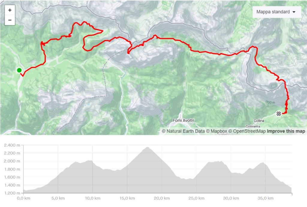
From the Val Visdende base camp, follow the tarmac road in the direction of the Restaurant da Plenta just before taking the forest road marked CAI path no. 138 in the direction of the Malga Chiastelin, which you reach by following the forest service road. From Malga Chiastelin you follow the malga path which, passing through Malga Antola, reaches Malga Chivon immediately after which you take the path which climbs up to Passo dell'Oregone. From here you reach Passo Sesis at altitude and then descend along the path through the splendid Fleons Valley until you reach Casera Fleonsdi Sotto from where the path starts, leading through the woods to Casera Sissanis. From the cheese factory, take the path up to Passo Sissanis from where there is a wonderful view of Lake Pera and the entire Volaia group. Once you have descended to Lake Pera below, take the path in the direction of Passo Giramondo and from here begins a long, steep descent into the Volaia Valley to the Volaier Alm cheese factory. Once at the cheese dairy, take the forest road up to Lake Volaia with a view of Monte Coglians and then, once you reach the Lambertenghi - Romanin hut, descend along path 144, which with a final descent leads to the base camp set up just before the village of Collina near the campsite.
DISTANCE
41.0 km
ELEVATION GAIN
2.557 m
TYPE OF TRAIL
5% asphalt - 15% forest track - 80% footpath
2nd STAGE
FROM VAL VISDENDE TO COLLINA DI FORNI AVOLTRI
From the Val Visdende base camp, follow the tarmac road in the direction of the Restaurant da Plenta just before taking the forest road marked CAI path no. 138 in the direction of the Malga Chiastelin, which you reach by following the forest service road. From Malga Chiastelin you follow the malga path which, passing through Malga Antola, reaches Malga Chivon immediately after which you take the path which climbs up to Passo dell'Oregone. From here you reach Passo Sesis at altitude and then descend along the path through the splendid Fleons Valley until you reach Casera Fleonsdi Sotto from where the path starts, leading through the woods to Casera Sissanis. From the cheese factory, take the path up to Passo Sissanis from where there is a wonderful view of Lake Pera and the entire Volaia group. Once you have descended to Lake Pera below, take the path in the direction of Passo Giramondo and from here begins a long, steep descent into the Volaia Valley to the Volaier Alm cheese factory. Once at the cheese dairy, take the forest road up to Lake Volaia with a view of Monte Coglians and then, once you reach the Lambertenghi - Romanin hut, descend along path 144, which with a final descent leads to the base camp set up just before the village of Collina near the campsite.
DISTANCE
41.0 km
ELEVATION GAIN
2.557 m
TYPE OF TRAIL
5% asphalt - 15% forest track - 80% footpath
3rd STAGE
FROM COLLINA TO PASSO PRAMOLLO
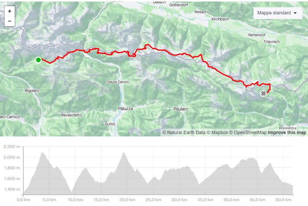
From the base camp in Collina, take the road descending the previous day to the Tolazzi Refuge. A little further on, follow the signs for the Marinelli Refuge and climb up the forest road. When you reach the Marinelli Refuge, descend first by path and then by forest road to the junction with path 146, which you follow as far as the Monte Croce Carnico Pass. From here, climb up along path 401 to Pal Piccolo and then continue along the same path to Casera Palgrande di Sopra and from here, again along the path to the Avostanis Pass. From the pass, descend to Lago Avostanis, from where you take the road down to Pramosio, but shortly after Casera delle Manze take the old military road to Passo Pramosio. From the pass, first descend along a firm and then a gradual path to the Obere Bischof Alm. At the cheese dairy, follow the signs to the Zollner Alm and on to the Zollner See. From here, the trail runs along the slope until it descends to the Straninger Alm and then takes the forest road to the Sella di Cordin. We remain on trail no. 403, which with ups and downs heads towards the Creta di Aip and Monte Cavallo via the Sella di Val Dolce and from here always at altitude to the Sella di Aip. We are now in the Passo Pramollo area in view of Monte Madrizze from which we descend following the path on ski slopes and then the forest road to Lago di Pramollo and from here for the last 2 km to the Baita Winkel hut where the base camp is set up.
DISTANCE
56.0 km
ELEVATION GAIN
3.633 m
TYPE OF TRAIL
2% asphalt - 30% forest track - 68% footpath
3rd STAGE
FROM COLLINA TO PASSO PRAMOLLO
From the base camp in Collina, take the road descending the previous day to the Tolazzi Refuge. A little further on, follow the signs for the Marinelli Refuge and climb up the forest road. When you reach the Marinelli Refuge, descend first by path and then by forest road to the junction with path 146, which you follow as far as the Monte Croce Carnico Pass. From here, climb up along path 401 to Pal Piccolo and then continue along the same path to Casera Palgrande di Sopra and from here, again along the path to the Avostanis Pass. From the pass, descend to Lago Avostanis, from where you take the road down to Pramosio, but shortly after Casera delle Manze take the old military road to Passo Pramosio. From the pass, first descend along a firm and then a gradual path to the Obere Bischof Alm. At the cheese dairy, follow the signs to the Zollner Alm and on to the Zollner See. From here, the trail runs along the slope until it descends to the Straninger Alm and then takes the forest road to the Sella di Cordin. We remain on trail no. 403, which with ups and downs heads towards the Creta di Aip and Monte Cavallo via the Sella di Val Dolce and from here always at altitude to the Sella di Aip. We are now in the Passo Pramollo area in view of Monte Madrizze from which we descend following the path on ski slopes and then the forest road to Lago di Pramollo and from here for the last 2 km to the Baita Winkel hut where the base camp is set up.
DISTANCE
56.0 km
ELEVATION GAIN
3.633 m
TYPE OF TRAIL
2% asphalt - 30% forest track - 68% footpath
4th STAGE
FROM BAITA WINKEL TO TARVISIO
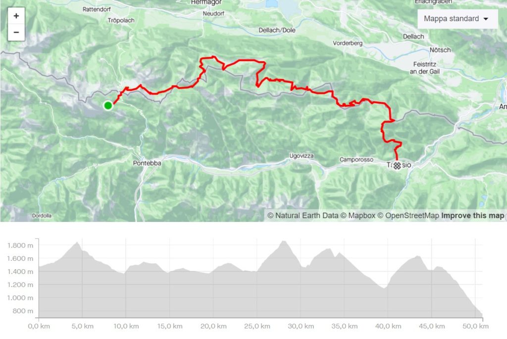
From the Winkel hut base camp, follow the road to Passo Pramollo and cross the road to take the forest road that climbs up to Gartner Settel. From here, descend to Garnizen Alm and then take the path that cuts across the ski slopes until you reach a stream, fording which a forest road begins that descends gently to Sella della Spalla. Shortly afterwards, leave the forest road to follow the path that leads to Sella Zille and once again take the forest road that goes past Sella Chersnizze and the alpine hut of the same name down to the village of Keserei Egger Alm. From here, follow the forest road to the right, which leads in the direction of Sella Poludnig to the Egger Alm lake in clear view and consequently to the village of Dellacher Alm. At this point, take the tarmac road that climbs to the right in the direction of the Poludniger Alm, but after the first series of hairpin bends, when the road begins to level out, take a path that descends through the forest to the left until it joins a forest road, which you follow for a short distance until you find a fixed rope that descends to the stream below. Once the stream has been crossed, take the path again up into the forest, following the signs for Gortschacher Alm, until it crosses the forest road leading up to the village of the same name. After passing the little village, take the path that first ascends to the Starhand Saddle and then descends to the Lom Saddle. From here, take the forest path that climbs gradually to Sella Bistrizza below Monte Osternig and from here take the forest road up to the Madonna della Neve chapel from where you continue in the direction of Sella Plecia and then the village of the Acomizza cheese factory. Just before the casera, follow the signs for Sella di Bartolo, which is reached by a forest road on a pleasant descent and from which you continue first on the path and then on the forest road in the direction of Capin di Ponente for the final ascent. From Capin di Ponente you descend along a path until you cross the forest road which, to the right in the last 5 kilometres, passing through Sella Canton and Sella Borgo, will take you to the finish line in Tarvisio.
DISTANCE
50.0 km
ELEVATION GAIN
2.283 m
TYPE OF TRAIL
2% asphalt - 48% forest track - 50% footpath
4th STAGE
FROM BAITA WINKEL TO TARVISIO
From the Winkel hut base camp, follow the road to Passo Pramollo and cross the road to take the forest road that climbs up to Gartner Settel. From here, descend to Garnizen Alm and then take the path that cuts across the ski slopes until you reach a stream, fording which a forest road begins that descends gently to Sella della Spalla. Shortly afterwards, leave the forest road to follow the path that leads to Sella Zille and once again take the forest road that goes past Sella Chersnizze and the alpine hut of the same name down to the village of Keserei Egger Alm. From here, follow the forest road to the right, which leads in the direction of Sella Poludnig to the Egger Alm lake in clear view and consequently to the village of Dellacher Alm. At this point, take the tarmac road that climbs to the right in the direction of the Poludniger Alm, but after the first series of hairpin bends, when the road begins to level out, take a path that descends through the forest to the left until it joins a forest road, which you follow for a short distance until you find a fixed rope that descends to the stream below. Once the stream has been crossed, take the path again up into the forest, following the signs for Gortschacher Alm, until it crosses the forest road leading up to the village of the same name. After passing the little village, take the path that first ascends to the Starhand Saddle and then descends to the Lom Saddle. From here, take the forest path that climbs gradually to Sella Bistrizza below Monte Osternig and from here take the forest road up to the Madonna della Neve chapel from where you continue in the direction of Sella Plecia and then the village of the Acomizza cheese factory. Just before the casera, follow the signs for Sella di Bartolo, which is reached by a forest road on a pleasant descent and from which you continue first on the path and then on the forest road in the direction of Capin di Ponente for the final ascent. From Capin di Ponente you descend along a path until you cross the forest road which, to the right in the last 5 kilometres, passing through Sella Canton and Sella Borgo, will take you to the finish line in Tarvisio.
DISTANCE
50.0 km
ELEVATION GAIN
2.283 m
TYPE OF TRAIL
2% asphalt - 48% forest track - 50% footpath